This is the log of my western vacation in September 2010. Some of my own photographs are included and some from Wikipedia.
Before we hit the road from Glenwood, we made a stop at the Glenwood Walmart for some supplies. We did take the time to take some mountain pictures in the beautiful morning light. We saw a good bit of town, and Dad had some good stories about the area from past trips he'd taken. Then he drove us out of town to the west on I-70.

It seems like the Glenwood Canyon marks the edge of the most massive of the Rocky Mountains. The mountains west of Glenwood are more spread out, and show more features of the Great Basin Desert (like sagebrush, mostly). The road continues to follow the Colorado River (which has its headwaters, by the way, in Rocky Mountain National Park).

We turned north off the interstate in the town of Rifle (Dad liked the name). We went north on CO 13, up to Meeker. This road started out in a dry, rocky desert area with many buttes and formations, but as we approached Meeker we climbed in elevation and entered a greener cattle range. In Meeker we turned west on CO 64. We passed (and stopped at) the Rangely Reservoir, and had a pleasant chat with a local who told us about the local wildlife. This area is hilly desert country once again. Then we picked up US 40 at Dinosaur and took that west towards Utah. This road is high desert, and starts to flatten out. A large, rocky reef parallels this road to the north all the way into Utah (the edge of the Yampa Plateau), and large mountains were visible to the north west. Behind that ridge is Dinosaur National Monument. We didn't stop this time.
Our lunch stop was in Vernal, UT. For someone from Pennsylvania, Vernal doesn't quite live up to its name, but the Green River coming through town does make it much greener than the surrounding desert. Vernal is a big town, definitely the biggest we saw all day until we got to Jackson.

I took over the drive from Vernal, and we went north on US 191. We climbed immediately, passing through a large reef in the Utah badlands, then switching back as we climbed the foothills of the Uinta Mountains. As the road climbs, it passes from the Utah desert to a greener mountain forest. We stopped close to the edge of this, to view the desert from an overlook with some information about local phosphorous mining.
191 passes through the Uintas before arriving in Wyoming, and this area is high, green and rugged. We saw quite a few campers in the thick lodgepole forests, and some cattle as well.

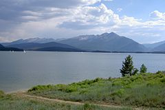
We turned left on UT 44, to see the west side of the Flaming Gorge National Recreation Area, and were glad we did. There's many switchbacks coming down from the Uintas to the gorge, and a nice overlook along the way, from which we took this picture. Off in the far distance we could see Flattop Mountain, and many other buttes and peaks in the Wyoming desert. The Gorge itself is a large lake, full of speedboats and fishermen. Actually, you see quite a few lakes in the west full of speedboats.

Once we dropped into the Gorge and started along the river, the terrain flattened out and continued to do so as we went north. We passed a few farms near the Green River, near the town on Manila. Once we passed through there, we paralleled the river on UT 530 to the north. There's nothing but sagebrush, grass, and rocks through here. The speed limit goes up to 70 (on a two-lane road), and there's no reason why you couldn't do 90. There are buttes and formations on the west side of the road here, and the gorge/lake are off to the distance in the east. We saw our first antelope in this section, and found something on the map called the Greater Green River Intergalactic Spaceport. No sign of any spaceships though.
We stopped in Green River, where I-80 passes through, and took the interstate west several exits. The speed limit is 75 here. Then we turned north on UT 372, to US 189. This is a fun stretch of road; it's absolutely barren. The rock formations are gone here, and there is nothing but a flat, desolate plain of sagebrush. You can see the signs of mining off in the distance, and gas and oil wells throughout. We did 80 mph this whole stretch, and you hardly even notice thanks to the openness.

Once we got about to the town of La Barge though, we started to see mountains both to the west and east. There were quite a few large, snowcapped peaks to the northeast, part of the Wind River Range. The distances were probably a hundred miles to each, but that range and the Wyoming Range on the west meet in the north, between La Barge and Jackson. Once we passed the Fontenelle Reservoir, we started to notice some badlands as the ground gained elevation.
We made a few neat sightings in this section. First, a large wildfire was burning on the back of one of the mountains to the west, and the smoke was noticeable even in the valley we were passing through, thirty miles away. Further north yet, a large thunderstorm was blowing up over the Wyomings. We managed to escape with just a few raindrops, but it was fun to see the cumulonimbus and lightnings on the wide open prairie.
We hit US 191 in the town of Daniel, then crossed the headwaters of the Green River and crossed a continental divide into the Snake River basin. This was a gentle desert pass, with mountains closing to the east and west. As they did, the terrain got greener and greener. Finally we were squeezed into the Hoback River canyon as it dropped towards Jackson Hole. This is quite a tight, high canyon - very scenic.
around.

Once you pop out of the Hoback, you're in Jackson. Or at least its suburbs. Yes, Jackson has suburbs, mostly ranches surrounding Grand Teton park. The Hoback River joins the Snake south of Jackson, and although it's not part of the Hole (nor nearly as wide), the valley here is flat, wooded and lovely. You don't have to go too far north here until you're into two lane highway, with businesses all
The best part of coming in this way though, is that the Teton Range is entirely hidden the hole time, due to East Gros Ventre butte just to the west of town. In downtown Jackson, we could see the top of Grand Teton itself for just a minute, but we never saw the range at all this day. And instead of going to look, we found our hotel (the El Rancho), ate at the Silver Dollar steakhouse, and called it a night. Quite a day of driving!