 Name: Fields Run Trail
Location: Sproul State Forest, Centre County, Pennsylvania
Date: Saturday, December 30, 2006
Click on any of the pictures for a closeup.
Between Karthaus in Clearfield County and Renovo in Clinton County, a number of streams drain the highlands of the Allegheny Plateau into the West Branch of the Susquehanna River. These streams start from springs in the rocks at the top of the plateau and then fall over 1300 feet to the river through gorgeous canyons. The rugged terrain makes access very difficult, making these stream beds excellent places for a wilderness hike.
 One of those streams is Fields Run. Falling to the West Branch on its southeastern shore from Centre County, Fields Run starts near SR 144 in Burnside Township, and falls approximately 1400 feet to the West Branch near the ghost town of Birch. It is paralleled by the Fields Run Trail, an old logging road cleared near the turn of the century. The trail is completely unmarked, and almost completely overgrown for the first 1.5 miles. Later, it provides access for a number of small camps and cabins and shows signs of occasional vehicular use.
The stream is small for the first mile an a half, winding through intermittent patches of mountain laurel and hemlocks. This is excellent territory to find the Ruffed Grouse, the official bird of Pennsylvania. This game bird is about the size of a chicken and dwells on the ground, eating berries, seeds and insects. They can fly with great speed and take off at the last moment, surprising the unwary hunter with the rush of their wings. This headwater area of Fields Run is also the most likely place to see the whitetail deer or a wild turkey. I once came face to face with a Great Horned Owl in a tight patch of pines here.
 After the first mile and a half, the trail widens and meets another coming from the top of the ridge. Here is the first camp along the trail, the Fields Run Camp. This is the prototypical Pennsylvania hunting cabin, approximately fifteen feet square, with outhouse and deer pole. Directly below this camp, and picture to the right are the remains of an old splash dam, a logger's contraption designed to float a timber harvest to the river by flooding a small valley and "splashing" the logs downstream. The old dam and the logging trail in the creek bottom are the only remaining signs that logging ever took place here.
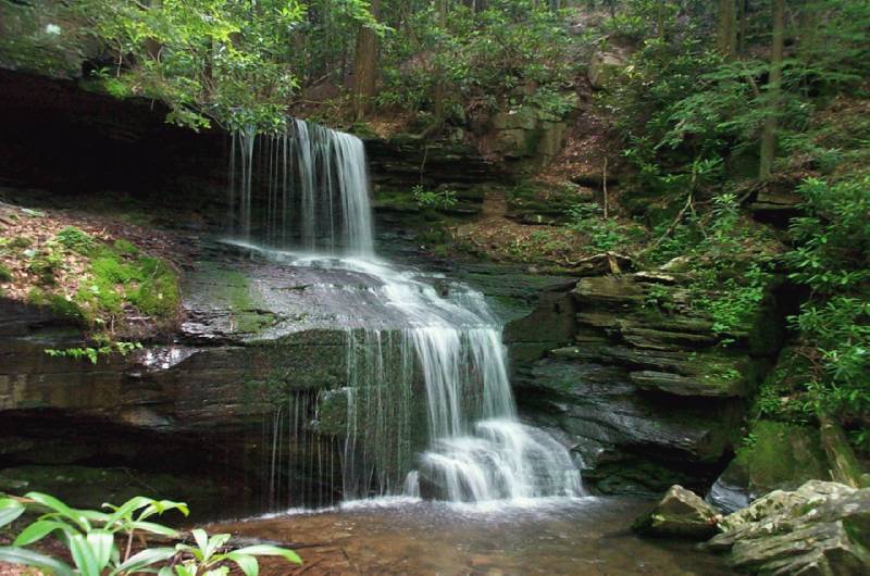
 From here, the path drops another 1100 feet over five miles as the valley sides get higher and steeper. Large boulders like the one on the left jut from the hillside, and cracks behind them and along the cliffs run back into the mountainsides. Who knows, perhaps there are even larger cave openings higher up the valleyside. Meanwhile, the stream gets larger and larger, being fed by several small drafts along the way, including Bog Ore Run, Burnt Shanty Run and Gaines Run. Tannic acid from leaves in the headwaters gives the stream a dusky color and reflects beautifully at times over the loose stony stream bottom.
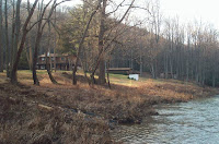 At six miles on the trail, the stream bottom opens up for half a mile before meeting the West Branch. The Gaines Trail drops down from Fields Ridge Road on the western ridge to several camps at the mouth of the creek. The Gaines Trail Camp, pictured here, sits on small piece of private property at the stream's mouth, accessible from the Gaines Trail via four wheel drive. The Gaines Trail leads back to the top of the ridge and the Fields Ridge Road, which provides a beautiful overlook of the river, facing to the west.
 The river cuts quite a gorge in this section as well. Here you can see the mouth of Fields Run and Yost Ridge, the eastern wall of the Fields Run Valley. This segment of the river is excellent for a canoe trip, with access points upstream in Karthaus and Rolling Stone and downstream in Keating and Renovo. Between Karthaus and Keating the river is only accessible by road or trail in a half dozen spots, making for a very lonely journey.


